rani799ah@gmail.com

Showing posts with label temperature. Show all posts

2016 well above 1.5°C

In December 2016, it was 6.58°C (11.84°F) warmer from latitude 83°N to the North Pole. In December 2016, the world as a whole was on average 0.82°C (1.47°F) warmer than in 1951-1980.


Temperatures are rising fast, and especially so over the Arctic Ocean. In February 2016, the world was 1.34°C (2.41°F) warmer than 1951-1980, while part of the Kara Sea was 11.3°C (20.34°F) warmer than 1951-1980, as the image on the right illustrates.

The 1951-1980 period is the default baseline used by NASA. When comparing the current temperature to years such as 1900 or 1750, the difference will be even larger, as illustrated by the image below.

In 2016, the global temperature was well above the 1.5°C (2.7°F) guardrail set by the Paris Agreement. This is illustrated by the different baselines used in image below (the use of different baselines was discussed in an earlier post), given that the Paris Agreement uses preindustrial levels as baseline.


[ click on images to enlarge ]
To some extent, the rise above 1.5°C was due to El Niño, as the trendline indicates, but the trend also indicates that temperatures will cross the 1.5°C mark in 2017 even if 2017 will be El Niño/La Niña-neutral.

Worryingly, another El Niño is actually forecast for 2017, as discussed in an earlier post.

Even more worrying is that rise of this trendline could well be too conservative.

Ocean temperatures are rising rapidly, as illustrated by the image on the right, and the rapid warming of the oceans is causing a dramatic fall in sea ice extent, as illustrated by the image below and as discussed in an earlier post.

The lack of sea ice spells trouble. Not only is snow and ice decline causing more sunlight to be absorbed (rather than getting reflected back into space as before), there are further feedbacks associated with this. As the temperature difference between the Arctic and the Equator decreases, changes are taking place to wind patterns that cause further acceleration of warming in the Arctic, as discussed in an earlier post. This in turn threatens to trigger huge amounts of methane to erupt abruptly from the seafloor.

Methane levels over the Arctic Ocean are much higher than over the rest of the world, as illustrated by the image below, showing the situation in the afternoon of January 17, 2017, with peaks reaching levels as high as 2406 ppb. Particularly worrying are the solid magenta-colored areas over the East Siberian Arctic Shelf, indicating methane levels above 1950 ppb.


When also taking into account further elements that could cause warming, a potential warming of 10°C (18°F) could eventuate by the year 2026, i.e. within about nine years from now, as discussed at the extinction page and as illustrated by the image below, from the Temperature page.


The situation is dire and calls for comprehensive and effective action, as described at the Climate Plan.


Links

• Climate Plan
http://arctic-news.blogspot.com/p/climateplan.html

• Extinction
http://arctic-news.blogspot.com/p/extinction.html

• Temperature
http://arctic-news.blogspot.com/p/temperature.html

• Accelerating Warming of the Arctic Ocean
http://arctic-news.blogspot.com/2016/12/accelerating-warming-of-the-arctic-ocean.html

• Global sea ice extent falling off chart
http://arctic-news.blogspot.com/2017/01/global-sea-ice-extent-falling-off-chart.html

• How much warming have humans caused?
http://arctic-news.blogspot.com/2016/05/how-much-warming-have-humans-caused.html


Global sea ice extent falling off chart

Global sea ice extent is falling off the chart, as illustrated by the image below.

[ click on images to enlarge ]
The National Snow & Ice Data Center (NSIDC) is one of the world's best-know archives for satellite data on sea ice.

In its recent news release, NSIDC notes that the difference between the 1981-2010 average global sea ice extent and the 2016 extent was over 4 million km² in mid-November 2016 (image on the right).

The fall in sea ice extent constitutes a huge amount of energy that is no longer reflected back into space and is instead absorbed by the ocean, the atmosphere and by the process of melting itself.

In line with earlier calculations by Professor Peter Wadhams, a 4 million km² sea ice decrease could equate to a radiative forcing of as much as 1.3 W/m². All this extra energy does not directly translate into a rise in temperature of the atmosphere, since a lot of energy has over the past few decades been absorbed by the ocean and has also gone into the process of melting itself. However, it now looks like the temperature of the atmosphere is catching up fast, as illustrated by the image below.


[ click on images to enlarge ]
On the right is a forecast by the European Centre for Medium-Range Weather Forecasts (ECMWF).

It shows that we've barely been in a La Niña, which typically makes the atmosphere cooler than it would otherwise have been.

Already now, another El Niño is on the way that could soon make it up to 2.5°C warmer than it is was late last year.

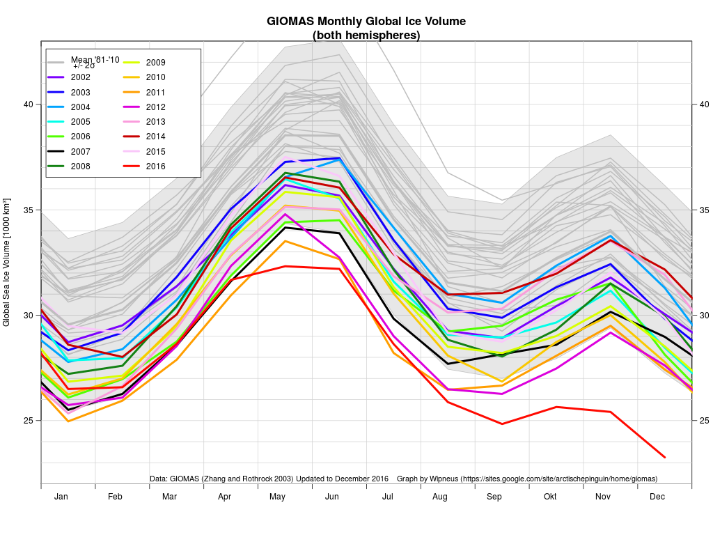
Global sea ice volume is also at record low, as illustrated by the image below on the right.
Arctic sea ice thickness hit a record low in November 2016 when thickness fell below 0.7 m or 2.3 ft.

As the ice gets thinner, the risk of collapse grows, as increasingly stronger winds and storms and stronger wave action can more easily break up thin sea ice, making it more vulnerable to melting and to get carried out of the Arctic Ocean by stronger cyclonic winds and stronger exit currents.

Disappearance of Arctic sea ice increases the risk of huge methane releases from the seafloor of the Arctic Ocean. The outlook is terrifying. As I calculated last year, surface temperatures of the atmosphere could rise by some 10°C or 18°F within a decade, i.e. by 2026.

The situation is dire and calls for comprehensive and effective action, as described in the Climate Plan.


Links

• Climate Plan
http://arctic-news.blogspot.com/p/climateplan.html

• Extinction
http://arctic-news.blogspot.com/p/extinction.html

• How much warming have humans caused?
http://arctic-news.blogspot.com/2016/05/how-much-warming-have-humans-caused.html


Over 20 of the most terrifying images of 2016

Remember the Paris Agreement? It was sealed on 12 December 2015, when nations triumphantly pledged to strengthen the global response to the threat of climate change, by "holding the increase in the global average temperature to well below 2°C above pre-industrial levels and pursuing efforts to limit the temperature increase to 1.5°C above pre-industrial levels, recognizing that this would significantly reduce the risks and impacts of climate change."


Months before the Paris Agreement was sealed, temperatures had already risen to more than 1.5°C above pre-industrial levels. Meanwhile, temperatures have been above the 1.5°C guardrail for most of the year 2016, i.e. for seven out of eleven months and this may well become eight out of twelve months once the full data for December 2016 is available. It was more than 1.5°C (2.7°F) warmer than pre-industrial for 10 out of the 14 months from October 2015 to November 2016.

The situation is dire. Little or no action is taken on climate change. Earth faces a potential temperature rise of more than 10°C or 18°F by 2026.

[ click on images to enlarge or go to original post ]

The situation in the Arctic is critical. While Earth as a whole is experiencing rapid warming, warming in the Arctic is escalating even faster and this rise is accelerating, due to feedbacks such as snow and ice demise and destabilizing sediments at seafloor of the Arctic Ocean. These sediments contain huge amounts of methane in the form of hydrates and free gas.

Albedo changes associated with decline of Arctic sea ice and snow and ice cover on land in the Arctic could lead to a 1.6°C warming, while methane eruptions from the seafloor could well cause an additional 1.1°C temperature rise over the next decade.

This temperature rise will trigger further feedbacks such as a rise of water vapor in the atmosphere. Water vapor is a potent greenhouse gas that will further accelerate the temperature rise. In combination with further elements, the danger adds up to a potential global temperature rise of 10°C or 18°F by 2026.

The danger is described in more detail at the Extinction page. Below are further images illustrating the danger.

Potential temperature rise of more than 10°C or 18°F by 2026 (from: Climate Plan Summary, see also: the extinction page)

Over the entire year 2016, warming was most profound over the Arctic Ocean, which was more than 2.5°C or 4.5°F warmer than 1981-2010, as illustrated by the image on the right.

The Arctic is hit particularly hard by warming. Warming of the air over the Arctic Ocean is taking place much faster than elsewhere on Earth, as illustrated by the animation underneath on the right.

This animation shows how this anomaly developed over the past few years, each time showing a 365-day period, starting in 2014 and each time shifted by roughly one month.

On November 19, 2016, the Arctic was 7.3°C or 13.14°F warmer than it was in 1979-2000, as the image below shows.

On that day, the Arctic Ocean in many places showed temperature anomalies at the top end of the scale, i.e. 20°C or 36°F warmer than it was in 1979-2000.

From the post Accelerating Warming of the Arctic Ocean.

These high temperatures over the Arctic Ocean reflect warm water of the Arctic Ocean, with heat added from the Atlantic Ocean and the Pacific Ocean. The image below shows the warming of the oceans. Temperatures are rising particularly rapidly on the Northern Hemisphere.

[ Ocean warming, from earlier post ]
The huge amounts of energy entering the oceans translate into higher temperatures of the water and of the air over the water, as well as higher waves and stronger winds. The North Atlantic Ocean is warming up rapidly and much ocean heat is carried by the Coriolis force along the Gulf Stream from the coast of North America through the North Atlantic into the Arctic Ocean.

The image below, from an earlier post, shows sea surface temperature anomalies on August 12, 2016, in the left-hand panel, and sea surface temperature anomalies in the right-hand panel.

Sea surface temperature and anomaly. Anomalies from +1°C to +2°C are red, above that they turn yellow and white
Above image also shows that on August 12, 2016, sea surface temperatures near Svalbard (at the location marked by the green circle) were as high as 18.9°C or 65.9°F, an anomaly of 13.6°C or 24.4°F.


Above image shows on October 31, 2016, sea surface temperatures near Svalbard (at the location marked by the green circle) were as high as 187°C or 62.7°F, an anomaly of 13.9°C or 25°F.

The image on the right shows that sea surface temperatures near Svalbard (green circle) were as high as 14.1°C or 57.3°F on December 6, 2016, 12.1°C or 21.7°F warmer than in 1981-2011.

This rise in ocean heat contributes strongly to the demise of Arctic snow and ice cover, and threatens to trigger ever larger eruptions of methane from the seafloor of the Arctic Ocean.

Thick sea ice covered with snow can reflect as much as 90% of the incoming solar radiation. After the snow begins to melt, and because shallow melt ponds have an albedo (or reflectivity) of approximately 0.2 to 0.4, the surface albedo drops to about 0.75. As melt ponds grow and deepen, the surface albedo can drop to 0.15, while the ocean reflects only 6% of the incoming solar radiation and absorbs the rest.


Over the past few years, trends have been pointing at zero thickness soon, i.e. in a matter of years. Rapid loss of sea ice thickness has taken place over the years, as discussed in a recent post. A trend based on PIOMAS volume data (preliminary for 2016) points at zero sea ice by end 2021, as illustrated by the graph below.


Collapse of the sea ice could well occur much earlier than the trend indicates. Thin sea ice is more vulnerable to the stronger storms that can be expected to hit the Arctic Ocean during the northern summer more frequently, and they could push huge amounts of ice out of the Arctic Ocean.

The sea ice also acts as a heat buffer, by absorbing energy in the process of melting. In other words, as long as there is sea ice, it will absorb heat and this will prevent this heat from raising the temperature of the water in the Arctic. Once the sea ice is gone, this latent heat must go elsewhere.

As the sea ice heats up, 2.06 J/g of heat goes into every degree Celsius that the temperature of the ice rises. While the ice is melting, all energy (at 334J/g) goes into changing ice into water and the temperature remains at 0°C (273.15K, 32°F).

Once all ice has turned into water, all subsequent heat goes into heating up the water, at 4.18 J/g for every degree Celsius that the temperature of water rises.

The amount of energy absorbed by melting ice is as much as it takes to heat an equivalent mass of water from zero to 80°C.

Arctic sea ice volume has now decreased so much that this buffer is now largely gone and that a lot more heat will be absorbed by the Arctic. Sea ice acted as a buffer that used to consume massive amounts of ocean heat carried along sea currents into the Arctic Ocean. A huge amount of energy used to be absorbed by this buffer, i.e. by melting ice and transforming it into water. The energy that used to be absorbed by melting ice is as much as it takes to warm up an equivalent mass of water from zero°C to 80°C. Without sea ice to consume heat, the heat must go somewhere else. Much of this heat will then suddenly speed up warming of the water of the Arctic Ocean, rather than going into melting the ice as it did previously. So, the water of the Arctic Ocean will suddenly warm up dramatically. Remember that the Arctic Ocean in many areas is very shallow, in many places it's less than 50 m deep, as discussed in an earlier post.

[ The Buffer has gone, feedback #14 on the Feedbacks page ]
Disappearance of the sea ice would mean that the buffer has gone, further increasing the danger of huge abrupt releases of methane from the seafloor of the Arctic Ocean. The danger is that this extra heat will reach the seafloor and destabilize methane hydrates that are contained in sediments at the bottom of the Arctic Ocean. This could result in huge methane eruptions. It is hard for methane plumes to get broken down in the water, given the abrupt and concentrated nature of such releases and given that the Arctic Ocean is in so many places very shallow. Once that methane enters the atmosphere, it will strongly contribute to further warming of the atmosphere over the Arctic.

As the water of the Arctic Ocean keeps warming, the danger increases that methane hydrates at the bottom of the Arctic Ocean will destabilize. As said, increases in temperature due to albedo changes and methane releases in the Arctic will go hand in hand with further feedbacks, including increased levels of water vapor in the atmosphere, warmer river water running into the Arctic Ocean and more soot from wildfires that will settle on the remaining sea ice.


Above image shows sea surface temperature anomalies in the Arctic (latitude 60°N-90°N) on October 9, 2016, compared to 1961-1990.


Above image shows sea surface temperature anomalies in the Arctic (latitude 60°N-90°N) on September 18, 2016, compared to 1961-1990.


Above image shows sea surface temperature anomalies in the Arctic (latitude 60°N-90°N) on September 4, 2016, compared to 1961-1990.


Above image shows sea surface temperature anomalies in the Arctic (latitude 60°N-90°N) on August 16, 2016, compared to 1961-1990.


Sea surface temperatures west of Svalbard were as high as 14.6°C (58.2°F) on December 29, 2016. Sea surface temperature went up at the end of December at this spot, while the longer-term average went down in line with the change in seasons. From the post: Accelerating Warming of the Arctic Ocean


Above image shows sea surface temperature as high as 14.6°C or 58.2°F on December 29, 2016, near Svalbard, as a result of warm water being pushed from the North Atlantic into the Arctic Ocean. From the post: Accelerating Warming of the Arctic Ocean.


Above image, from an earlier post, illustrates how a cold freshwater lid on the North Atlantic could result from stronger evaporation, in combination with meltwater, causing more heat to get carried into the Arctic Ocean underneath the sea surface, due to reduced heat transfer to the atmosphere from water on its way to the Arctic Ocean.
(view more images at the methane page)
Note that there is a huge lack of monitoring of the situation regarding methane in the Arctic. Above image shows high methane levels recorded at Barrow, Alaska, that were later removed by NOAA.

While there may be uncertainty, due to limited availability of data, such uncertainty does not make the problem go away. The situation is critical; in many respects, we can just count ourselves lucky that much larger methane eruptions haven't occurred as yet. 

The image on the right shows historic growth rates of methane (CH4), carbon dioxide (CO₂) and nitrous oxide (N2O). Methane levels increased most (256% of 1750 levels in 2015, red), much more than carbon dioxide (144% of 1750 levels in 2015, blue) or nitrous oxide (121% of 1750 levels in 2015, green).

The image below shows the recent situation, with trends pointing at an increase in the methane burden by a third by 2030 and a doubling by 2040.

[ click on images to enlarge or go to original post ]
Why again is methane so important? On a 10-year timescale, methane causes more warming than carbon dioxide. Unlike carbon dioxide, methane's Global Warming Potential rises as more of it is released. Methane's lifetime can be extended to decades, in particular due to depletion of hydroxyl in the atmosphere.

[ click on images to enlarge or go to original post ]
Ominously, methane levels were very high over the Laptev Sea (solid magenta color north of Siberia) on November 9, 2016. The image below also shows that on November 9, 2016, methane levels were as high as 2633 parts per billion.
[ click on images to enlarge or go to original post ]
As the water of the Arctic Ocean keeps warming, the danger increases that methane hydrates at the bottom of the Arctic Ocean will destabilize.


The danger is further illustrated by the two images above and below, recorded by the MetOp2 satellite on the afternoon of Christmas eve and Christmas.


Continued warming could trigger huge abrupt methane eruptions leading to mass destruction and extinction.

To top it off, the image below shows that growth in CO₂ levels appears to be accelerating.

[ click on images to enlarge or go to original post ]
According to NOAA, mean global carbon dioxide grew from 2004-2014 by an average 2.02 ppm per year. For 2015 the growth rate was 2.98 ppm. As an indication for what the 2016 growth rate will be, global CO₂ levels grew by 3.57 ppm between September 2015 and September 2016, and by 3.71 ppm between October 2015 and October 2016.

[ Potential temperature rise from preindustrial to 2026. For details see original post and the Temperature page.
The final two images show a potential temperature rise from preindustrial to 2026 of 9.7°C (annual average) and 10.02°C (monthly peak), and below a prognosis of the number of climate-related global deaths in line with the action taken.

[ click on images to enlarge or go to original post ]

The situation is dire and calls for comprehensive and effective action as described at the Climate Plan.


Links

A pdf of the extinction page and a summary of the Climate Plan can be downloaded from
https://sites.google.com/site/samcarana/climateplan/Climate-Plan-by-Sam-Carana.pdf?attredirects=0&d=1

 Climate Plan
https://arctic-news.blogspot.com/p/climateplan.html

 Climate Plan - Summary
http://arctic-news.blogspot.com/p/summary.html

 Methane
https://arctic-news.blogspot.com/p/methane.html

 Extinction
https://arctic-news.blogspot.com/p/extinction.html

 FAQs (Frequently asked questions)
http://arctic-news.blogspot.com/p/faq.html

 Seafloor Methane

Monthly CO₂ not under 400 ppm in 2016

For the third year in a row, global carbon dioxide emissions from fossil fuels and industry (including cement production) have barely grown, as the Global Carbon Project image below shows:


Nonetheless, CO₂ levels have continued to rise and, as illustrated by the trend on the image below, they may even be accelerating.


According to NOAA, annual mean global carbon dioxide grew from 2004-2014 by an average 2.02 ppm per year. For 2015 the growth rate was 2.98 ppm. As an indication for what the 2016 growth rate will be, global CO₂ levels grew by 3.57 ppm between September 2015 and September 2016, and by 3.71 ppm between October 2015 and October 2016. How could growth in CO₂ levels in the atmosphere possibly be accelerating, given that emissions from fossil fuel burning and cement production have barely risen over the past few years?

Deforestation and other land-use changes, in particular wildfires

During the decade from 2006 to 2015, emissions from deforestation and other land-use change added another 1.0±0.5 GtC (3.3±1.8 GtCO₂) on average, on top of the above emissions from fossil fuel and cement. In 2015, according to the Global Carbon Project, deforestation and other changes in land use added another 1.3 GtC (or 4.8 billion tonnes of CO₂), on top of the 36.3 billion tonnes of CO₂ emitted from fossil fuels and industry. This rise in emissions from deforestation and other changes in land use constitutes a significant increase (by 42%) over the average emissions of the previous decade, and this jump was largely caused by an increase in wildfires over the past few years.

In 2016, monthly mean global CO₂ levels didn't get below 400 ppm. It was the first time that this happened in over 800,000 years.


On their way up, global CO₂ levels fluctuate with the seasons, typically reaching an annual minimum in August. In August 2016, CO₂ levels reached a low of 400.44 ppm, i.e. well above 400 ppm. In September 2016, carbon dioxide levels had gone up again, to 400.72 ppm. Importantly, a trend is contained in the data indicating that growth is accelerating and pointing at a CO₂ level of 445 ppm by the year 2030.

Sensitivity

Meanwhile, research including a 2014 study by Franks et al. concludes that IPCC was too low in its estimates for the upcoming temperature rise locked in for current CO₂ levels. A study by Friedrich et al. updates IPCC estimates for sensitivity to CO₂ rise, concluding that temperatures could rise by as much as 7.36°C by 2100 as a result of rising CO₂ levels.

When also taking other elements than CO₂ more fully into account, the situation looks to be even worse than this, i.e. the global temperature rise could be more than 10°C (or 18°F) over the coming decade, as further described at the extinction page.

Land sink


Above image also shows an increase of the land sink over the years, which a recent study attributes to higher CO₂ levels in the atmosphere. While this increase of the land sink appears to have held back a stronger temperature rise for some time, there are indications that this land sink is now decreasing. A recent study suggests that some 30 ± 30PgC could be lost from the top 10 cm surface soil for a 1°C, and some 55 ± 50 PgC for a 2°C rise of global average soil surface temperatures, which would increase CO₂ levels in the atmosphere by some 25 ppm. The study adds that, since high-latitude regions have the largest standing soil C stocks and the fastest expected rates of warming, the overwhelming majority of warming-induced soil C losses are likely to occur in Arctic and subarctic regions. See also the video below for more on this study.

In other words, land is now taking up less carbon and is contributing more and more to global warming:
  • Deforestation and Soil Degradation: Agricultural practices such as depleting groundwater and aquifers, plowing, mono-cultures and cutting and burning of trees to raise livestock can significantly reduce the carbon content of soils, along with soil moisture and nutrients levels.
  • Climate change and extreme weather events: The recent jump in global temperature appears to have severely damaged soils and vegetation. Soil carbon loss and enhanced decomposition of vegetation appear to have occurred both because of the temperature rise and the resulting extreme weather events such as heatwaves, drought, dust-storms and wildfires, and storms, hail, lightning, flooding and the associated erosion, turning parts of what was once a huge land sink into sources of CO₂ emissions. Even worse, such extreme weather events can also lead to emissions other than CO₂ emissions, such as of soot, nitrous oxide, methane and carbon monoxide, which can in turn cause raise levels of ground-level ozone, thus further weakening vegetation and making plants even more vulnerable to pests and infestations.
  • Albedo: As a 2009 study warned, higher temperatures could also cause decreased canopy transpiration, due to less widely opened plant stomata and the resultant increase in stomatal resistance at higher atmospheric CO₂ concentrations. As a result, low cloud cover is decreasing over most of the land surface, reducing planetary albedo and causing more solar radiation to reach the surface, thus further raising temperatures beyond the level of viability for many species. At the same time, the above extreme weather events are causing more water vapor to rise high in the atmosphere, resulting in cirrus clouds that reflect only little sunlight back into space, while trapping more heat (i.e. surface radiation emitted as longwave energy into space). Furthermore, emissions such as dust and soot from wildfires and storms can settle on snow and ice, resulting in faster melting.


Explanation of Quantifying global soil carbon losses in response to warming (1 December 2016) by lead author Thomas Crowther from the Netherlands Institute of Ecology (NIOO-KNAW) and Yale University.

Conclusion

In conclusion, while CO₂ emissions from fossil fuels and industry may have barely grown, levels of greenhouse gases are steadily increasing, if not accelerating. At the same time, extreme weather events are on the rise and there are further factors contributing to cause the land carbon sink to shrink in size. Furthermore, the IPCC appears to have underestimated sensitivity to CO₂ rise.

Rising Temperatures

Without action, temperatures can therefore be expected to rise further, rather than come down from their currently already very high levels, as illustrated by the image below.


The image below shows the temperature rise of the oceans. Temperatures are rising particularly rapidly on the Northern Hemisphere. Much of that heat is carried by the Coriolis force along the Gulf Stream toward the Arctic Ocean.

[ click on images to enlarge ]
This contributes to a huge rise in the temperature of the atmosphere over the Arctic Ocean, as illustrated by the images below. The image directly below shows showing temperature rises up to 10.2°C in the Arctic for October 2016.


The DMI graph below shows daily mean temperature and climate north of the 80th northern parallel, as a function of the day of year.

Red line: 2016 up to November 15, 2016.  -   Green line: climate 1958-2002.

On November 19, 2016, on 00.00 UTC, the Arctic was as much as 7.54°C or 13.57°F warmer than it was in 1979-2000, as illustrated by the image below.


The image below shows the average temperature on November 19, 2016. The Arctic was 7.3°C or 13.14°F warmer than it was in 1979-2000, illustrating the accelerating warming of the Arctic Ocean. The Arctic Ocean in many places shows temperature anomalies at the top end of the scale, i.e. 20°C or 36°F.


Global sea ice

As another reflection of an increasingly warmer world, the combined extent of Arctic and Antarctic sea ice is currently at a record low. On November 12, 2016, combined global sea ice extent was only 23.508 million km².


On November 18, 2016, combined Arctic and Antarctic sea ice extent was only 22.608 million km². That's a fall of 0.9 million km² in six days!


Two images, created by Wipneus with NSIDC data, are added below to further illustrate the situation.

Above image shows global sea ice extent over the years, while the image below shows global sea ice area over the years. For more on the difference between extent and area, see this NSIDC FAQ page.

Some of the consequences of the dramatic global sea ice decline are:
  • More Ocean Heat: Huge amounts of sunlight that were previously reflected back into space are now instead absorbed by oceans.
  • Faster Melt: Decline of the sea ice makes it easier for warm sea water to get underneath glaciers and speed up their flow into the water.
  • Stronger Storms: More open water results in stronger storms, causing rainfall and further decline of the snow and ice cover, as well as greater cloud cover at high altitudes, resulting in more warming.
  • More Methane: Further decline of the snow and ice cover on Greenland and Antarctica in turn threatens to cause increased releases of methane from Greenland and Antarctica, as described in earlier posts such as this one. Furthermore, continued warming of the Arctic Ocean threatens to cause huge eruptions of methane from its seafloor.
Methane

While carbon dioxide emissions get a lot of attention (and they definitely must be cut rapidly and dramatically), the rise of methane is possibly even more worrying. The image below shows historic growth rates of methane (CH4), carbon dioxide (CO₂) and nitrous oxide (N2O).


According to NOAA data, annual mean global methane grew from 2004-2013 by an average of 3.75 ppb per year. In 2014, the growth rate was 12.56 ppb. In 2015, the growth rate was 10.14 ppb. According to the WMO, methane's 2014–2015 absolute increase was 11 ppb. For more on methane, see the methane page.

The situation is dire and calls for comprehensive and effective action, as described in the Climate Plan.


Links

 Greenhouse gas levels and temperatures keep rising
http://arctic-news.blogspot.com/2016/01/greenhouse-gas-levels-and-temperatures-keep-rising.html

 Climate Feedbacks Start To Kick In More
http://arctic-news.blogspot.com/2016/06/climate-feebacks-start-to-kick-in-more.html

 Pursuing Efforts?
http://arctic-news.blogspot.com/2016/10/pursuing-efforts.html

 Methane hydrates
http://methane-hydrates.blogspot.com/2013/04/methane-hydrates.html

 Wildfires in Russia's Far-East
http://arctic-news.blogspot.com/2016/08/wildfires-in-russias-far-east.html

 Methane
http://arctic-news.blogspot.com/p/methane.html